


Garmin Gpsmap 7408 J1939 Display 8 Multifunction Touchscreen
High performance 8” multifunction display
- Large 8” capacitive multitouch display (1024 x 600 WSVGA) with preloaded worldwide basemap
- High sensitivity GPS/GLONASS 10Hz receiver
- Garmin Marine Network integration via NMEA 2000® and NMEA 0183 support
- Supports GSD™ and GCV™ sonar modules
- Advanced functions for sailing navigation
Designed for powerboats and sailboats, the GPSMAP 7408 chartplotter, with a large 8” capacitive multitouch display, features a built-in high-sensitivity GPS/GLONASS receiver that updates position and heading 10 times per second. It connects to the Garmin Marine Network via NMEA 2000 and offers the convenience of Wi-Fi® connectivity for using Garmin apps.
Additional features with BlueChart® g2 Vision
Thanks to the optional BlueChart g2 Vision cartography, you can take advantage of extra features such as:
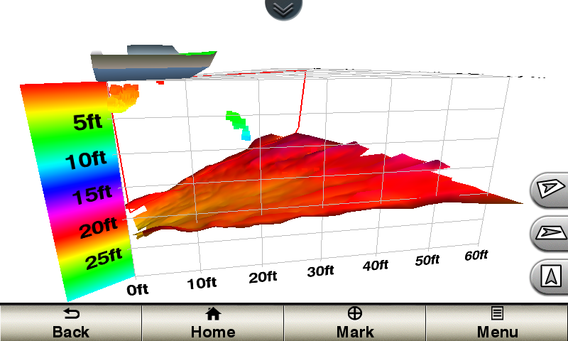
- 3D Mariner's Eye and Fish Eye view above and below sea level.
- High-resolution satellite images and aerial photographs that ensure better orientation during navigation.
- Auto Guidance technology for calculating the optimal route.
- Fishing maps with detailed contour lines
Garmin Marine Network and NMEA 2000
By connecting the GPSMAP 7408 to the Garmin Marine Network, it is possible to view on the display the data processed by the on-board instruments such as radar, autopilots, depth sounder modules, multimedia devices (FUSION-Link), thermal imaging cameras, GRIDs and much more. The GPSMAP 7408 also lets you share information with other compatible GPSMAP units, such as maps and user data, including waypoints, routes and tracks. This means that user data entered into the GPSMAP 7408 can automatically synchronize with other chartplotters on the network.
Direction and position updated 10 times per second
The GPSMAP 7408 is equipped with a high-sensitivity 10Hz GPS receiver capable of simultaneously locating GNSS, GPS, GLONASS, Galileo and QZSS satellite systems thus providing accurate position data within 3 m. The integrated 10 Hz GPS receiver updates the position and direction 10 times per second, this guarantees a more fluid display of the boat's movements, guaranteeing enormous advantages even at very low speeds.
gWind™ transducers and sail functions
The new Garmin gWind transducers have a double direction vane and a front-reading anemometer to provide maximum precision in any wind condition. They connect to the Garmin Marine Network via NMEA 2000 protocol and are compatible with the GPSMAP 7408 via the GND™ 10 black box. Supported sailing functions include lay lines, compass rose, COG and HDG vector display, as well as data fields of real and apparent wind.
Auto Guidance 3.0
Auto Guidance technology automatically calculates the safest and most reliable route to reach your destination. The Auto Guidance function, using the cartographic data, automatically works out the best route and avoids any obstacles along the way. From today, this Garmin-exclusive feature offers even more functionality and features in version 3.0. With Auto Guidance 3.0 you have the possibility to modify a route, review the most dangerous points, view the estimated navigation times at any point of the suggested route; save planned routes. Auto Guidance 3.0 is included in BlueChart® g2 Vision cartography
SOS safety assist
The unique SOS safety assist function makes it easier for anyone - even those unfamiliar with on-board electronics - to quickly call for help in an emergency situation. By simply touching the SOS key on the plotter's touchscreen display, a list of possible situations is immediately displayed (fire on board, Man Overboard, etc.). Once an option has been selected, the display, if connected to the VHF with DSC (Digital Selective Calling) function, will send a distress call to the Coast Guard, indicating the GPS coordinates of the boat and all the essential and necessary information to request timely assistance .
Transfer of waypoints in GPX format
If you have waypoints, tracks or routes stored on another manufacturer's GPS or an old Garmin GPS, it's now easier than ever to import them to your new Garmin plotter, using the data in GPX format. The GPX format is an open standard medium for exchanging GPS data between different platforms and applications. With this evolution, you are guaranteed that all important data stored on an old instrument is preserved and transferred to your new Garmin device
Specific functions for sailing
Thanks to the new page dedicated to the world of sailing, you can access innovative regatta functions, which will guide you to make a perfect start and make winning decisions: the starting line, the laylines, the timer and the regatta countdown. In addition, other features included in the sail page are wind rose, heading and course line (COG) display, leeward heading and speed display, true and apparent wind data fields, and more. You can also use the available built-in wireless connectivity to access and control a variety of marine-specific apps via compatible smartphones or tablets.
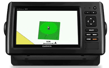
Panoptix™ Down transducer
The innovative Panoptix PS30 Down transducer represents the absolute innovation for navigation safety and an indispensable aid for the most demanding fishermen. Thanks to the Panoptix Down transducer, it is possible, in fact, to view everything under the boat in real time. It allows you to take advantage of 3 types of visualizations with an extraordinary level of detail and almost photographic precision: LiveVü Down, RealVü 3D Down and RealVü 3D Historical.
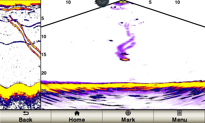
Live Vü Down
It provides real-time images of everything under the boat. Allows you to view fish approaching or moving away from your boat.
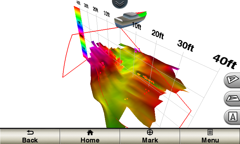
RealVü 3D Down
Provides a real-time 3D view of everything below and around your vessel.
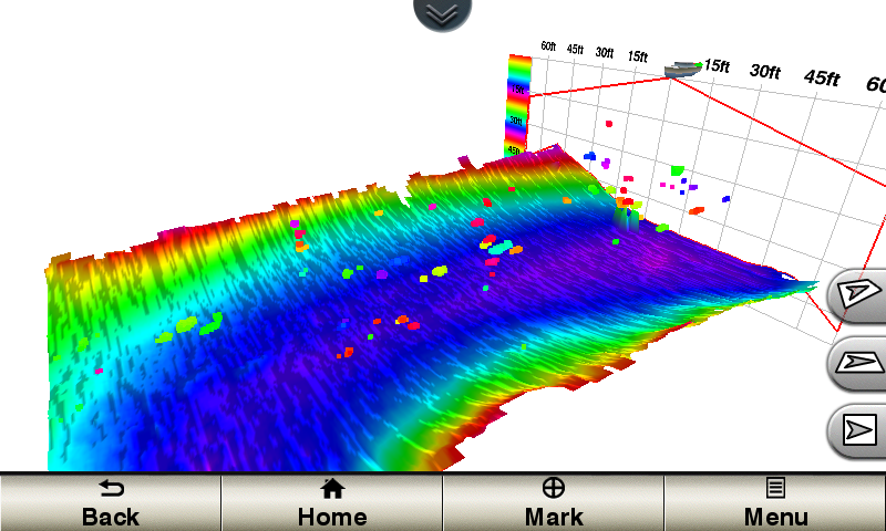
RealVü 3D Historical
This is the function used to find fish when the boat is moving. Scan and view in 3D the entire history of everything that has passed under the boat, from the bottom to the surface.
Panoptix™ Forward transducer
The latest generation Panoptix PS31 Forward transducer represents the absolute innovation for navigation safety and guarantees an indispensable aid to the most demanding fishermen. In fact, it allows you to scan and display in real time everything in front of the boat: the seabed, obstacles and moving fish. It allows you to use 2 different types of views with an exceptional level of detail and almost photographic precision: LiveVü Forward and RealVü 3D Forward.
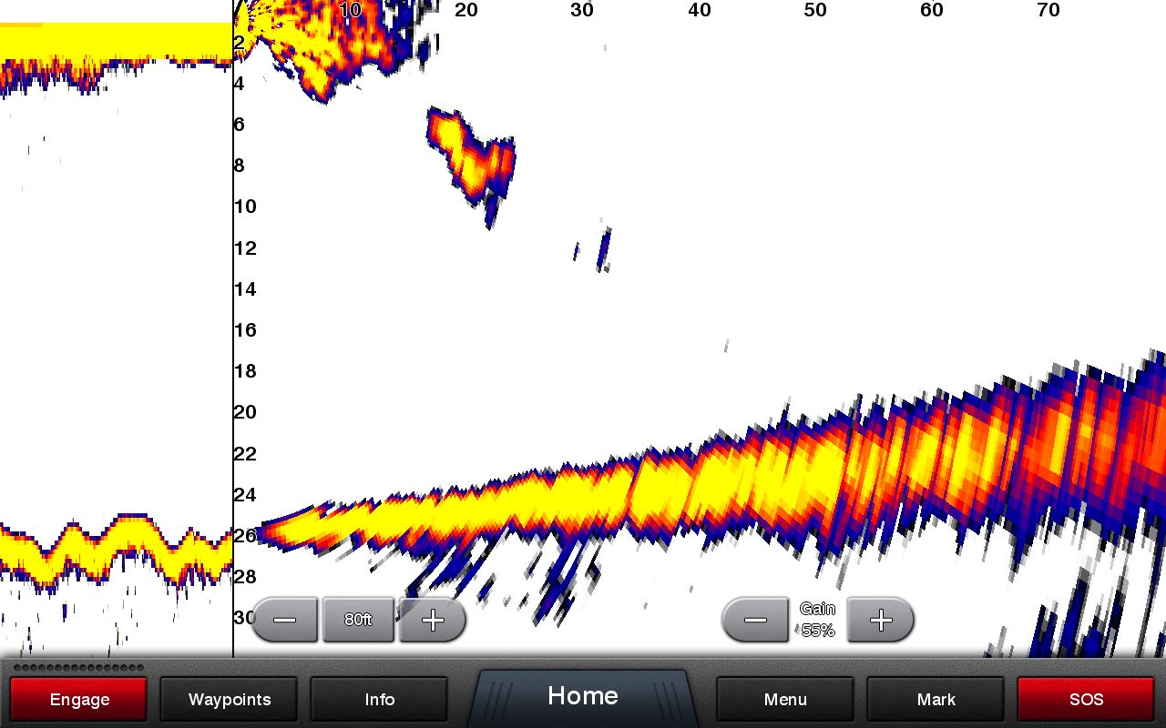
LiveVü Forward
Provides precise and detailed real-time images of everything in front of the boat such as moving fish or any type of obstacle.
RealVü 3D Forward
Provides a real-time 3D view of everything ahead of the bow of the boat.
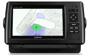
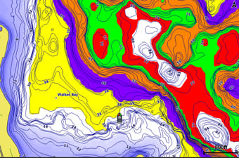
Create your own HD maps
Quickdraw Contours is a free, easy-to-use software feature that comes pre-installed on your Garmin. Instantly create your own custom HD fishing maps with 1-foot depth contours. Customize them according to your needs. They are your maps. They belong to you. Keep the data to yourself or share it with the Quickdraw Community on Garmin Connect ™ . No special topography experience is required. You only have to think about fishing while this feature creates the maps. You don't have to wait and you don't have to send your files elsewhere as required by other mapping programs: the results are visible instantly. You can use it with any Garmin Panoptix™ transducer, HD-ID™ sonar with CHIRP technology, Garmin ClearVü™, or NMEA 2000® compatible depth transducer. You have multiple fishfinders installed on board Quickdraw Contours automatically selects the most effective to provide you with optimal results.
Shading on different depths
Define up to 10 depth ranges by assigning each one a different color. Makes it easy to see target depth at a glance.
Activate the autopilot from the chartplotter
You can manage the autopilot activation process more easily and conveniently from the chartplotter screen.
Support for AXIS and FLIR cameras
Garmin offers support for some Axis and FLIR cameras. These can be used for surveillance and situational awareness purposes on vessels of any size. You can control multitouch and pan/tilt settings by interacting directly with the plotter screen, display video on multiple screens, and stream multiple videos on the same screen. Use an Axis encoder to convert your analog camera, such as the Garmin GC 10, into video over IP
Capture all the action experienced on the water
Thanks to the wireless function of your chartplotter you can connect the Garmin VIRB® action camera to record all the action of your day on the boat. Thanks to the new software update, you can check the recording, capture still images and stream the video you just shot directly to the display of your GPSMAP® 7400 series or 8000/8400 series chartplotter. You can play video from 4 VIRB action cameras and stream them simultaneously to your compatible chartplotter. There's also an automatic slideshow mode and the ability to delete images or videos from VIRB that you no longer want to keep. Each VIRB can be assigned a name to make it easier to identify. You can also change the video settings of VIRB cameras, including aspect ratio, video resolution, frames per second, photo format, field of view and more directly from the chartplotter. You can also send your vessel's NMEA 2000 network data from the chartplotter to VIRB and overlay it as G-Metrix™ data onto video using VIRB Edit or the VIRB mobile app.
Make your boat smart
Use the new ActiveCaptain™ application to connect your Garmin Marine chartplotter to the mobile network and make your boat smart. ActiveCaptain™ is free and will allow you to make the most of your onboard equipment. Thanks to OneChart™ you can consult the nautical cartography directly from your mobile device; you can also buy new areas and automatically synchronize them with the chartplotter on board your boat. With ActiveCaptain™ you will have a community all to yourself: connect with the ActiveCaptain community to get updated information on marinas and new points of interest, download and share bathymetrics thanks to the Garmin Quickdraw™ Contours feature. You can also plan your navigation in advance from the comfort of your home; save and transfer routes and waypoints between the app and the chartplotter without pressing a button. Receive Smart Notifications, calls and SMS directly on the display of your Garmin Marine chartplotter; you can also view and control the chartplotter from your smartphone or tablet thanks to the Helm function. Receive notifications about software updates and decide when to download them to your device without having to use your computer anymore
iPhone and iPad are trademarks of Apple Inc. App Store is a service mark of Apple Inc. Android and Google Play are trademarks of Google Inc. Wi-Fi is a registered trademark of the Wi-Fi Alliance.
General |
|
| Dimensions | 24.4 x 16.0 x 7.6cm |
|---|---|
| Weight | 1.40kg |
| Waterproof classification |
IPX7 |
| Screen type | wsvga extension |
| Screen size, WxH | 8 - 17.8 x 10.2 cm |
| Screen resolution, WxH | 1024 x 600 pixels |
| Energy consumption |
|
| GPS antenna | Internal_or_external_over_NMEA_2000 |
| Mounting options | On bracket, flush or recessed |
| Receiver |
10Hz GPS/GLONASS |
| Garmin Marine Network™ ports |
2 |
Maps and memory |
|
| External memory |
2 SD™ cards |
|---|---|
| Waypoints | 5,000 |
| Memorable routes | 100 |
| Track logs | 50,000 points; 50 saved tracks |
| Cartography preloaded |
Worldwide basemap |
Functions for outdoor activities |
|
| Tide data | |
|---|---|
Chartplotter functions |
|
| Compatible with Garmin radars | |
|---|---|
| Compatible with Garmin black boxes |
Yes (when connected to another compatible sonar device) |
| Garmin SmartMode compatible (customizable monitor presets) | |
| Compatible with AIS function | |
| Compatible with DSC function | |
| Compatible with Garmin Meteor audio system | |
| Fusion Lync | |
| Compatible with GSD™ blackboxes | |
| Compatible with GCV™ blackboxes | |
| BlueChart® Mobile | Yes |
| Garmin Helm | Yes |
| GRID™ (Garmin Remote Input Device) | |
| Wireless connectivity | |
Sonar functions and specifications |
|
| Double frequency | Yes_(when_connected_to_another_compatible_sonar_device) |
|---|---|
| Double cone | Yes_(when_connected_to_another_compatible_sonar_device) |
| CHIRP | Yes_(when_connected_to_another_compatible_sonar_device) |
| ClearVü |
Yes (when connected to another compatible sonar device) |
| SideVü |
Yes (when connected to another compatible sonar device) |
Connections |
|
| NMEA 2000® | |
|---|---|
| NMEA 0183 inputs | 2 |
| NMEA 0183 output | 2 |
| Video input |
1 - Composite |
| Video output | Nobody |
| Wireless connectivity | Yes |
Additional features |
|
| Additional features |
|
|---|---|

How the shipments of the items ordered on our site work.
All the information you need regarding cost, times and delivery methods.
Shipping Times
Toysfun.it guarantees, depending on the availability of the product in the warehouse, the shipment within an interval ranging from a minimum of 12 hours to a maximum of 5 working days.
How is this time estimated?
In addition to availability, the time needed to manage the order must also be taken into account. Orders with the fastest delivery are those made with online payment (Credit Card and PayPal - and cash on delivery).
Different payment methods and delivery methods may change the shipping time. For example, for orders with delayed payment, such as bank transfers, the shipping date may vary by a few days, as these orders are processed upon receipt of payment confirmation.
Couriers
Once the order has been placed and the payment and delivery methods have been selected, it is processed and the product is entrusted to the courier for shipment where indicated when completing the order.
Couriers for Italy SDA, Crono, TNT, Liccardi, GLS, BRT, Fercam
The shipping cost is €8.00 per shipment.
Goods receipt
You can check the status of your orders at any time in the Personal Area section by viewing the order details. Some small tips for receiving the goods:
Check that the number of packages delivered corresponds to what is indicated in the transport document.
Check that the packaging is intact and not altered even in the closing tapes. In the event of tampering and/or breakage, you must immediately contest the shipment and/or delivery by adding the words "GOODS INSPECTION RESERVE FOR ..... (indicate the reason)" on the delivery document received from the courier or from another operator.
Subsequently you will have to report any damage within 7 (seven) days of receipt by sending an email to ecommprojectagency@gmail.com